
January severe weather event
** UPDATE EXTRA 6.30pm 22 January**
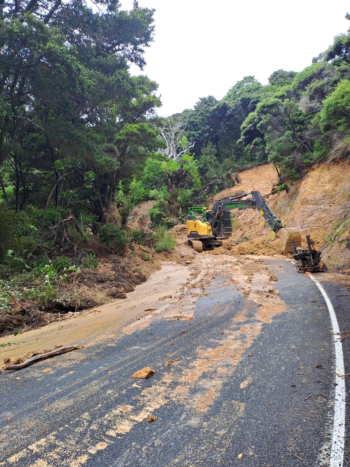
Rawhiti Road bridge at Ngaiotonga.
Rawhiti Road north of the Ngaiotonga bridge has now been cleared and is accessible by large trucks. This means that more than 40 truckloads of material can be delivered from Russell quarry and work to reinstate the bridge abutment washed away by flash floods on Saturday night can begin. Initially, materials were to be delivered to the southern side of the bridge, but that route has proved to be inaccessible due to ongoing slips. Contractors will be working every day from now and over the long weekend to get the job completed as soon as possible so that the critical Rawhiti Road link between Russell in the north and coastal communities in the south can be reopened.
**FINAL UPDATE 3pm 22 January**
Far North District Council will stand down its Emergency Operations Centre (EOC) this afternoon now that torrential rains that hit the district on Saturday night have passed. This will be the final update for this weather event.
The EOC acted as the ‘nerve centre’ managing the council’s response to weather-related emergencies alongside Civil Defence Northland, FENZ and neighbouring councils.
A smaller Incident Management Team will remain in operation over coming days to coordinate recovery efforts for communities with lasting impacts from the weather event.
Just two roads remain closed: Rawhiti Road is closed by both a slip and the washed-out bridge abutment at Ngaiotonga. Work is continuing to reinstate the bridge. A slip has also closed Russell-Whakapara Road. That should reopen to one lane this afternoon.
Numerous other roads across the district remain impacted by slips and other obstructions but all are now open at least on one lane.
We will continue to provide updates on recovery efforts and weather-related road works in coming days.
**UPDATE 1:30 pm 22 January **
Contractors continue to assess and clear slips and debris across the district, with additional resources now working in the Russell and Rawhiti areas. Crews have increased to five teams in the Russell area, with work focused on Rawhiti Road (North and South), stabilising Manawaora Road and progressing slip clearance on Russell-Whakapara Road.
A fallen tree earlier blocked Wainui Road. Crews have now cleared the road, with further overslip clearance continuing through the day.
Rawhiti Road (South), Russell-Whakapara Road and Waikare Road remain closed while repairs and slip clearance continue. Other roads may be restricted to residents, single lane operation or 4WD access in affected areas as work progresses.
Road | Road Status | Cause | Description |
OKURA BAY ROAD | 4WD Access only | Overslip | Mud is on the road in places. 4WD is recommended and drive with care. |
PUPUKE MANGAPA ROAD | Single lane operation | Overslip | A slip is affecting one lane. Expect delays and follow any traffic control. |
TAURANGA BAY ROAD | Road Open | Road obstruction | Debris is on the road. Please drive with care. |
TAURANGA BAY ROAD | Road Open | Road obstruction | Debris is on the road. Please drive with care. |
WAINUI ROAD | Single lane operation | Overslip | A slip is affecting one lane. Expect delays and follow any traffic control. |
WAINUI ROAD | Road Open | Underslip | Damage on the road edge. Please drive with care. |
WAINUI ROAD | Road Open | Road obstruction | Debris is on the road following flooding. Please drive with care. |
WAINUI ROAD | Road Open | Overslip | A slip is affecting the road edge. Please drive with care. |
WAINUI ROAD | Road Open | Road obstruction | Debris is on the road. Please drive with care. |
WAINUI ROAD | Road Open | Overslip | A slip is affecting the road edge. Please drive with care. |
WAINUI ROAD | Road Closed | Fallen Tree | A fallen tree is blocking the road. Please avoid the area. |
WAINUI ROAD | Road Open | Fallen Tree | A fallen tree is on the road shoulder. Please drive with care. |
WAINUI ROAD | Single lane operation | Overslip | A slip is affecting one lane. Expect delays and follow any traffic control. |
WAINUI ROAD | Single lane operation | Overslip | A slip is affecting one lane. Expect delays and follow any traffic control. |
WAINUI ROAD | Road Open | Overslip | A slip is affecting the road shoulder. Please drive with care. |
WAINUI ROAD | Single lane operation | Overslip | A slip is affecting one lane. Expect delays and follow any traffic control. |
WAINUI VALLEY ROAD | Road Open | Bridge Damage | Road is open but there is damage near a culvert. Please take extra care. |
Some localised power outages are affecting small numbers of customers and restoration is expected this afternoon.
If your life or property is in danger call 111. To report slips, flooding or hazards call the council’s 24-hour call centre on 0800 920 029.
**UPDATE 9.30am 22 January**
Weather warnings have now been lifted for the North Island and Far North District Council contractors are out assessing our local road network. State Highways in the Far North are open but please monitor the NZTA-Journey Planner website if you plan to travel.
Three local roads are currently closed due to slips, washouts or other obstructions. Rawhiti Road remains closed while repairs to the bridge at Ngaiotonga are completed and a separate slip on that road is also being cleared. Other roads closed are: Russell-Whakapara Road and Waikare Road.
Contractors have identified 23 sites impacting the local roading network with some roads affected by two or more slips, washouts or other obstructions. The full list is below.
We have four road crews clearing roads today in the most heavily impacted areas around coast south of Russell. One closure occurred overnight in the Elliots Bay area. Contractors aim to restore that road to one lane this morning. Another minor slip is being attended this morning on Arabella Rd at Ōpua. Four roading crews are also checking flood prone sites and responding to flooding reports in the southern and western parts of the Far North roading network. Our northern network has been largely unaffected, although there was flooding in Kāeo south. The State Highway has reopened. A Wainui Valley Rd community has been cut off due to flood waters. This affecting approximately 16 households.
Road | Road Status | Cause | Description |
ARABELLA ROAD | Width Restriction Only | Overslip | Overslip to be cleared, minor. |
CALLAGHANS ROAD | 4WD Access only | Flooding | flooding, known locations |
HIKUWAI ROAD | Road Open | Road obstruction | pavement damage by excess water from hills, scouring pavement - passable without 4wd required. |
KNUDSENS ROAD | Road Open | Fallen Tree | trees damaged by wind |
MANAWAORA ROAD | Residents Only | Overslip | Overslips lanes closed |
MANAWAORA ROAD | Road Open | Overslip | numerous slips , medium-large, clearing underway. |
MAROMAKU-TOWAI ROAD | 4WD Access only | Flooding | flooding, known locations |
MASONS ROAD | 4WD Access only | Flooding | flooding, known locations |
MATAWAIA-MAROMAKU ROAD | 4WD Access only | Flooding | flooding, known locations |
NGAPIPITO ROAD | Road Open | Fallen Tree | Tree down, blocking road. Currently open to one lane. |
NINIHI ROAD | 4WD Access only | Flooding | localised flooding, known location |
OTAUA ROAD | Width Restriction Only | Flooding | localised flooding, known location |
RAWHITI ROAD (NORTH) | Residents Only | Overslip | Numerous overslips throughout section, some underslips to be assessed. |
RAWHITI ROAD (SOUTH) | Residents Only | Overslip | Numerous overslips , some underslips to be assessed. |
RAWHITI ROAD (SOUTH) | Road Closed | Overslip | multiple overslips during night of 21jan. |
RAWHITI ROAD (SOUTH) | Road Closed | Bridge Damage | Bridge Abutment washout |
RENWICK ROAD (SIDE ROAD) | Residents Only | Flooding | localised flooding, known location |
RUSSELL-WHAKAPARA ROAD | Road Closed | Overslip | numerous overslips occurring in narrow carriageway/gorge section. |
TAWATA ROAD | Residents Only | Flooding | localised flooding, known location |
TOKAWHERO ROAD | Road Open | Fallen Tree | tree down. |
WAIKARE ROAD | Road Closed | Road obstruction | Road washed out |
WAIOMIO ROAD (WAIOMIO) | Residents Only | Flooding | flooding, signs notifying. |
WHAREPUNGA ROAD | Width Restriction Only | Flooding | localised flooding, known location |
WHIU ROAD | Residents Only | Flooding | localised flooding, known location |
**UPDATE 9.50pm 21 January**
Road Closure: SH 10 Kaeo & Kerikeri-Waipapa
Flooding: Due to flooding, State Highway 10 is closed in both directions near Omaunu Rd and between Waipapa Rd and Kerikeri Rd. Please delay your travel. Monitor the NZTA-Journey Planner website as other state highways may be closed if rain continues.
**UPDATE 8.15pm 21 January**
MetService weather radar has detected severe thunderstorms near MATAURI BAY and WAINUI. These severe thunderstorms are moving towards the southeast, and are expected to lie near KAWAKAWA, TOWAI, WHANGARURU, ŌPUA and WAIHAHA at 08:22pm and near WHANGAREI, NGUNGURU, MATAPOURI, PATAUA and TAIHARURU at 08:52pm. These thunderstorms are expected to be accompanied by torrential rain.
Impact: Torrential rain can cause surface and/or flash flooding about streams, gullies and urban areas, and make driving conditions extremely hazardous.
Action: The National Emergency Management Agency advises that as storms approach you should:
- Take shelter, preferably indoors away from windows
- Avoid sheltering under trees, if outside
- Get back to land, if outdoors on the water
- Move cars under cover or away from trees
- Secure any loose objects around your property
- Check that drains and gutters are clear
- Be ready to slow down or stop, if driving.
During and after the storm, you should also:
- Beware of fallen trees and power lines
- Avoid streams and drains as you may be swept away in flash flooding.
Roading
As a precaution, the Matauri Bay campsite has been evacuated following a large slip on Matauri Bay Road. Campers are sheltering at Te Tāpui Marae, are safe and well, and will be checked on by council welfare and rapid response teams early tomorrow.
Bay Road and Tauranga Bay Road are currently impassable. A hillside slip has been reported on Beechy Road, Ōpua, adjacent to the community hall. This is currently under investigation.
**UPDATE 4.15pm 21 January**
Significant new slips have closed Manawaora Road and Russell-Whakapara Road on the east coast. The Manawaora Rd slip has cut off the peninsula and is being cleared as a priority. Contractors are aiming to have this cleared by 6pm to provide one-lane access to residents only. The other Russell-Whakapara Road slip will be cleared as soon as possible.
**UPDATE 4pm 21 January**
Twenty roads have been affected by ongoing heavy rainfall impacting the Far North. Of those two are closed, and 13 are down to one lane or are passable only by four-wheel drive vehicles. A full list is below.
The rain is also reducing the capacity contractors to undertake major repairs, delaying timelines on some projects.
The weather system has stabilised and while heavy rain is still being reported in some areas, rivers and streams have coped well so far. However, the Red Heavy Rain Warning remains in place until 11pm tonight and there remains a danger that there will be further slips and flooding. Far North residents are urged to call emergency services on 111 if they, their whānau, or their property are at immediate risk. If you need assistance, please call our 24-hour call centre on 0800 920 029.
There has been flooding in the wider Ōtaua-Punakitere-Waimatenui area as well as on roads in the south of the district. A bridge on Ōtaua Road has flooded.
Far North District Council’s Emergency Operations Centre will continue to operate tomorrow.
Road | Road Status | Cause | Description | Estimated Resolution | Planned Action |
CALLAGHANS ROAD | 4WD Access only | Flooding | flooding, known locations | 22/01/2026 | signed up, residents aware, assess |
NINIHI ROAD | 4WD Access only | Flooding | localised flooding, known location | 22/01/2026 | wait for water to recede, check access |
MASONS ROAD | 4WD Access only | Flooding | flooding, known locations | 22/01/2026 | signed up, residents aware, assess |
MATAWAIA-MAROMAKU ROAD | 4WD Access only | Flooding | flooding, known locations | 22/01/2026 | signed up, residents aware, assess |
MAROMAKU-TOWAI ROAD | 4WD Access only | Flooding | flooding, known locations | 22/01/2026 | signed up, residents aware, assess |
WAIOMIO ROAD (WAIOMIO) | Residents Only | Flooding | flooding, signs notifying | 21/01/2026 | wait for water to recede, assess |
RAWHITI ROAD (SOUTH) | Residents Only | Overslip | numerous overslips, some undercut | 31/01/2026 | clear overslips, restore full dual lane |
RAWHITI ROAD (NORTH) | Residents Only | Overslip | numerous overslips throughout | 24/01/2026 | clear slips and assess underslips |
TAWATA ROAD | Residents Only | Flooding | localised flooding, known location | 22/01/2026 | wait for water to recede, check access |
WHIU ROAD | Residents Only | Flooding | localised flooding, known location | 22/01/2026 | wait for water to recede, check access |
RENWICK ROAD (SIDE ROAD) | Residents Only | Flooding | localised flooding, known location | 22/01/2026 | wait for water to recede, check access |
WALKER ROAD | Road Closed | Road obstruction | road washed out | 21/01/2026 | close road, put signage up, fill |
RAWHITI ROAD (SOUTH) | Road Closed | Bridge Damage | bridge abutment washout | 31/01/2026 | repair in conjunction with FH |
KNUDSENS ROAD | Road Open | Fallen Tree | trees damaged by wind | 21/01/2026 | tree subcontractor to remove |
HIKUWAI ROAD | Road Open | Road obstruction | pavement damage by excess water | 24/01/2026 | grade & metal |
NGAPIPITO ROAD | Road Open | Fallen Tree | tree down blocking road | 18/01/2026 | NTW and fire brigade cleared |
MANAWAORA ROAD | Road Open | Overslip | numerous slips, medium-large | 27/01/2026 | clear slip material, restore dual lane |
TOKAHERO ROAD | Road Open | Fallen Tree | tree down | 21/01/2026 | clear tree and assess damage |
OTAUA ROAD | Width Restriction | Flooding | localised flooding, known location | 22/01/2026 | wait for water to recede, check access |
WHAREPUNGA ROAD | Width Restriction | Flooding | localised flooding, known location | 22/01/2026 | wait for water to recede, check access |
WAIKARE ROAD | Road closed | Bridge Damage | bridge abutment washout | 21/01/2026 | repair in conjunction with FH |
**UPDATE 12pm 21 January**
Fourteen Far North District roads have now been impacted by the severe weather affecting Northland with two roads closed and another eight restricted due to flooding, debris and fallen trees.
The two road closures include the Rawhiti Road bridge washout, which occurred on Sunday. Repairs to the bridge abutment have now begun and will require in excess of 40 track loads of material to be transported to the site. Work is continuing, however, a timeline for its completion is yet to be confirmed. Waikare Road, which is often used as an alternative route between Kawakawa and Russell, is also closed due to a road washout. Work is now underway to reopen the link. Alternative routes for this road are available. A full list of impacted roads is below.
Road | Road Status | Cause | Description |
CALLAGHANS ROAD | 4WD Access only | Flooding | flooding, known locations |
HIKUWAI ROAD | Road Open | Road obstruction | pavement damage by excess water |
KNUDSENS ROAD | Road Open | Fallen Tree | trees damaged by wind |
MANAWAORA ROAD | Single lane operati... | Overslip | numerous slips, medium and large |
MAROMAKU-TOWAI ROAD | 4WD Access only | Flooding | flooding, known locations |
MASONS ROAD | 4WD Access only | Flooding | flooding, known locations |
MATAWAIA-MAROMAKU ROAD | 4WD Access only | Flooding | flooding, known locations |
NGAPIPITO ROAD | Road Open | Fallen Tree | Tree down, blocking road. |
RAWHITI ROAD (NORTH) | Single lane operati... | Overslip | Numerous overslips throughout. |
RAWHITI ROAD (SOUTH) | Road Closed | Bridge Damage | Bridge Abutment washout |
RAWHITI ROAD (SOUTH) | Single lane operati... | Overslip | Numerous overslips |
TOKAWHERO ROAD | Road Open | Fallen Tree | tree down. |
WAIKARE ROAD | Road Closed | Road obstruction | Road washed out |
WAIOMIO ROAD (WAIOMIO) | Residents Only | Flooding | flooding, signs notifying. |
Do not enter floodwaters and avoid travel. Act quickly to self-evacuate if you see rising water. Be ready for power and communications outages.
Supporting information
- Civil Defence Northland Facebook page: https://www.facebook.com/civildefencenorthland
- Power outages: Check the Top Energy website for the latest on power outages in he Far North: https://outages.topenergy.co.nz/
- Northland Civil Defence web section: https://www.nrc.govt.nz/civildefence/
- Weather warnings: https://www.metservice.com/warnings/home#upper-north
- State highways: https://www.journeys.nzta.govt.nz/highway.../northland
- Local roads: Check your local council websites and Facebook pages
- Whangarei District Council| Phone: 0800 932 463 | Facebook: www.facebook.com/WhangareiDC | Website: www.wdc.govt.nz
- Far North District Council | Phone: 0800 920 029 | Facebook: www.facebook.com/FarNorthDistrictCouncil | Website: www.fndc.govt.nz
- Kaipara District Council| Phone: 0800 727 059 | Facebook: www.facebook.com/KaiparaDistrictCouncil Website: www.kaipara.govt.nz
**UPDATE 10am 21 January**
Council opens Emergency Operations Centre
Far North District Council has opened its Emergency Operations Centre (EOC), following Metservice warnings that severe weather is set to worsen.
The Kaikohe-based EOC will act as the nerve centre for the council’s response to any weather-related emergencies that may impact the district over the coming 24 to 36 hours.
The most recent MetService weather update issued at 9am this morning raised its warning to a Red Heavy Rain Warning for Northland until 11pm tonight. It predicts another 90-120mm of rain on top of what has already accumulated, possibly more in localised areas. It warns that the north and east will most likely be impacted. Localised downpours of 25-40mm per hour may occur this afternoon.
Far North District Council has not issued a local state of emergency at this stage.
However, it is warning Far North residents and visitors, especially those in remote locations, to avoid travel. If travel is required, they should first check for road closures and delays on district roads on the Far North District Council website, and on state highways via NZ Transport Agency Waka Kotahi journey planner website.
As of 10am today, only the Rawhiti Road bridge at Ngaiotonga remains closed on the Far North District road network. All other roads in the district are open. The council will be providing regular updates on road conditions on its website.
EOC staff will be contacting communities in affected areas regularly to confirm local conditions and any welfare needs.
Far North residents are urged to call emergency services on 111 if they, their whānau, or their property are at immediate risk. For more information about staying safe, and regular updates on weather-related events, visit the FNDC website January Severe Weather Event webpage. Updates will also be shared to the FNDC Facebook page, and Civil Defence Northland will post information as it becomes available.
**UPDATE 2pm 20 January**
MetService has updated its weather warning for Northland. There is now an Orange Heavy Rain Warning active until early Thursday morning.
Key messages
- Today (Tuesday) expect 60-80mm of rain with possible 25-40mm per hour downpours.
- Wednesday expect a further 120-160mm of rain and possible downpours of 25-40mm per hour.
- Streams and rivers may rise rapidly. Surface flooding, slips, and difficult driving conditions are possible.
The worst weather is expected tomorrow evening (Wednesday) and into Thursday morning. Far North District Council civil defence teams are prepared and are on standby. We will open our Emergency Operations Centre (EOC) if and when required.
What we are doing now
There are five crews from Ventia working in areas that were impacted from the flooding on Sunday clearing slips, debris, fallen trees, and clearing culverts as required in efforts to keep road access open.
Road network
We have received reports of nine issues impacting district roads following the weekend weather. Those roads and issues are:
- Manawaroa Rd – overslip – work underway
- Hikuwai Rd – debris – open
- Knudsens Rd – fallen tree – work underway
- Ngapipito Rd – fallen tree – open
- Rawhiti Rd (north) – overslip – open
- Rawhiti Rd (south) – bridge – closed
- Rawhiti Rd (south) – overslip – work underway
- Tokawhero Rd – fallen tree – work underway
- Waikare Rd – flooding – work underway
Critical assets and flood prone sites
In preparation for forecast heavy rains, our roading crews are checking critical assets around the district such as culverts where flooding is a known issue. Need to report an issue? Call our 24-hour call centre on 0800 920 029.
What you can do
- If you feel that you, your whānau, or your property are at immediate risk call emergency services on 111.
- Clear drains and gutters, and secure loose outdoor items.
- Move valuables and vehicles away from flood prone areas.
- Relocate stock from low lying land and bring pets indoors.
- Ensure you have a supply of drinking water, non-perishable food, portable radio, medication, chargers, portable cooker, torch, spare batteries, and cash on hand.
- Check on neighbours, especially older people or those who may need support – kia manaaki tātou i a tātou anō.
- Check highway and road conditions before you travel. Only travel if absolutely necessary.
- Be ready to move to higher ground if needed, and kaua rawa e taraiwai roto i ngā waipuke – never drive through floodwaters.
- If conditions worsen, Civil Defence centres or community hubs may be activated, including marae where appropriate. These places provide a safe space, information, and support if needed – he wāhi haumaru, he wāhi manaaki. Please wait for official confirmation before travelling to a hub.
- Report weather-related incidents to the council’s 24-hour call centre on 0800 920 029.
Rawhiti Road bridge approach
A specialist excavator needed to make repairs to the Rawhiti Road bridge is trapped on the southern side of Russell Road due to a significant slip. Until this slip is cleared, we cannot access the bridge approach to repair it. Repairs can only be made from the southern side of the bridge. This means the bridge is unlikely to reopen now until Wednesday afternoon or later. We are aware this is seriously impacting some residents and we are assessing welfare needs as a result. If you need assistance, please call our 24-hour call centre on 0800 920 029.
**UPDATE 4pm 19 Jan**
- Our engineers confirmed at midday today that the Rawhiti Road bridge is not damaged and that repairs can commence. Contractors are now moving material and specialist machinery to site so they can undertake the works without damaging the concrete structures around the bridge foundations. We anticipate reopening the bridge to traffic by late tomorrow (Tuesday) afternoon.
- Sixteen major road slips hit the Far North District road network as a result of sudden severe rains on Saturday and Sunday. A severe slip creates 500 square metres or more of debris.
- Further heavy rains are predicted over the next 48 hours and Far North District Council civil defence teams are on standby to respond to possible road closures and flooding incidents. Please avoid unnecessary travel and report any weather related incidents to our 24-hour call centre on 0800 920 029.
MetService has issued a Heavy Rain Watch for Northland starting 6pm tonight (Monday) and extending until noon Tuesday. Rainfall may approach Warning levels or possibly exceed them in some areas. Southeasterlies will be strong in exposed places. More rain is expected tomorrow and Wednesday and strong east to northeast winds may reach gale force.
We will be providing regular updates here on any flooding, road closures and civil defence notices as they occur. Please keep monitoring this page.
If your life or property is in danger, please call emergency services immediately on 111. Please report flooding, slips or other weather-related events to our 24-hour call centre on 0800 920 029.
To check for road closures and delays on state highways: https://www.journeys.nzta.govt.nz/journey-planner or follow NZ Transport Agency Waka Kotahi – Northland
Check the Top Energy website for the latest on power outages: https://outages.topenergy.co.nz/
Tags: Emergency